NERC Data Catalogue Service
The areas and volumes of 12,920 Asia Summer Monsoon (ASM) triggered landslides in Nepal. (NERC Grant NE/L002582/1)
Text file containing the areas (of combined scar, deposition and runnout zones, and estimated scar zones alone) and volumes (for both total and scar areas) of 12,920 Asia Summer Monsoon (ASM) that occurred across central-eastern Nepal in the period 1988 - 2018. Note, landslides were not mapped in the years 2011 and 2012 due to scan line errors in Landsat 7 imagery.
Default
Identification info
- Metadata Language
- English (en)
- Dataset Reference Date ()
- 2021-06-21
University of Plymouth
-
Joshua Jones
(
School of Geography, Earth and Environmental Sciences
)
Plymouth
,
- Maintenance and update frequency
- notApplicable
- GEMET - INSPIRE themes, version 1.0
- BGS Thesaurus of Geosciences
-
- Landslides
- NGDC Deposited Data
- Keywords ()
- Keywords
-
- NERC_DDC
- Limitations on Public Access
- otherRestrictions
- Other constraints
- licenceOGL
- Use constraints
- otherRestrictions
- Other constraints
- The copyright of materials derived from the British Geological Survey's work is vested in the Natural Environment Research Council [NERC]. No part of this work may be reproduced or transmitted in any form or by any means, or stored in a retrieval system of any nature, without the prior permission of the copyright holder, via the BGS Intellectual Property Rights Manager. Use by customers of information provided by the BGS, is at the customer's own risk. In view of the disparate sources of information at BGS's disposal, including such material donated to BGS, that BGS accepts in good faith as being accurate, the Natural Environment Research Council (NERC) gives no warranty, expressed or implied, as to the quality or accuracy of the information supplied, or to the information's suitability for any use. NERC/BGS accepts no liability whatever in respect of loss, damage, injury or other occurence however caused.
- Other constraints
- Available under the Open Government Licence subject to the following acknowledgement accompanying the reproduced NERC materials "Contains NERC materials ©NERC [year]"
- Spatial representation type
- textTable
- Topic category
-
- Geoscientific information
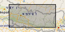
- Extent
-
NEPAL [id=497000]
- Dataset Reference Date ()
- 1979
- Extent
-
NP
- Dataset Reference Date ()
- 2009
- Extent
-
NPL
- Dataset Reference Date ()
- 2009
N
S
E
W
))
- Begin date
- 2018-10-01
- End date
- 2020-10-01
- Quality Scope
- dataset
- Other
- dataset
Report
- Dataset Reference Date ()
- 2011
- Explanation
- See the referenced specification
- Degree
Report
- Dataset Reference Date ()
- 2010-12-08
- Explanation
- See http://eur-lex.europa.eu/LexUriServ/LexUriServ.do?uri=OJ:L:2010:323:0011:0102:EN:PDF
- Degree
- Statement
- Landslides were mapped manually through visual interpretation of pre- and post-monsoon season Landsat 4/5/7/8 images, the dates of which are included within the text file. Scar areas were estimated using the methods of Marc & Hovius (2015) and Marc et al. (2018) (which estimate scar areas based on landslide widths), whilst volumes were calculated using the scaling relationships of Larsen et al. (2010). Note, landslides were not mapped in the years 2011 and 2012 due to scan line errors in the Landsat 7 imagery.ing the methods of Marc & Hovius (2015) and Marc et al. (2018), whilst volumes were calculated using the scaling relationships of Larsen et al., (2010).
Metadata
- File identifier
- c61206a0-9f89-5f2d-e054-002128a47908 XML
- Metadata Language
- English (en)
- Resource type
- dataset
- Metadata Date
- 2024-04-17
- Metadata standard name
- UK GEMINI
- Metadata standard version
- 2.3
British Geological Survey
Environmental Science Centre,Keyworth
,
NOTTINGHAM
,
NOTTINGHAMSHIRE
,
NG12 5GG
,
United Kingdom
+44 115 936 3100