NERC Data Catalogue Service
A century of groundwater accumulation in Pakistan and northwest India - dataset (NERC Grant NE/R000069/1)
The groundwater systems of northwest India and central Pakistan are amongst the most heavily exploited in the world. Groundwater has been monitored in the region for more than a century resulting in a unique long-term record of groundwater level change. The BGS has compiled groundwater level data from northwest India (Haryana and Punjab) and Pakistan (Punjab) between 1884 and 2020. The dataset, presented here, was compiled from various sources between 2018 and 2020. The excel file consists of two tabs both containing groundwater level data (in metres below ground level) and location information. In the first tab (Full_dataset), which contains the full dataset, there are 68783 rows of observed groundwater level data from 4028 individual sites. In the second tab (LTS) there are 7547 rows of groundwater level observations from 130 individual sites, which have water level data available for a period of more than 40 years and from which at least two thirds of the annual observations are available.
Default
Identification info
- Metadata Language
- English (en)
- Dataset Reference Date ()
- 2021-07-13
International Waterlogging and Salinity Research Institute, Pakistan Water and Power Development Authority
-
Muhammed Basharat
Lahore
,
Pakistan
British Geological Survey
-
Enquiries
0115 936 3276
The Lyell Centre, Research Avenue South
,
EDINBURGH
,
LOTHIAN
,
EH14 4AP
,
United Kingdom
0115 936 3142
0115 936 3276
British Geological Survey
-
Enquiries
0115 936 3276
The Lyell Centre, Research Avenue South
,
EDINBURGH
,
LOTHIAN
,
EH14 4AP
,
United Kingdom
0115 936 3142
0115 936 3276
- Maintenance and update frequency
- notApplicable
- GEMET - INSPIRE themes, version 1.0
- BGS Thesaurus of Geosciences
-
- Agriculture
- Groundwater
- NGDC Deposited Data
- Water resources
- Keywords ()
- Keywords
-
- NERC_DDC
- Limitations on Public Access
- otherRestrictions
- Other constraints
- licenceOGL
- Use constraints
- otherRestrictions
- Other constraints
- The copyright of materials derived from the British Geological Survey's work is vested in the Natural Environment Research Council [NERC]. No part of this work may be reproduced or transmitted in any form or by any means, or stored in a retrieval system of any nature, without the prior permission of the copyright holder, via the BGS Intellectual Property Rights Manager. Use by customers of information provided by the BGS, is at the customer's own risk. In view of the disparate sources of information at BGS's disposal, including such material donated to BGS, that BGS accepts in good faith as being accurate, the Natural Environment Research Council (NERC) gives no warranty, expressed or implied, as to the quality or accuracy of the information supplied, or to the information's suitability for any use. NERC/BGS accepts no liability whatever in respect of loss, damage, injury or other occurence however caused.
- Other constraints
- Available under the Open Government Licence subject to the following acknowledgement accompanying the reproduced NERC materials "Contains NERC materials ©NERC [year]"
- Spatial representation type
- textTable
- Topic category
-
- Geoscientific information
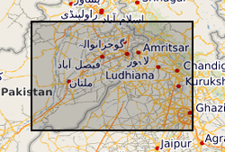
- Extent
-
PAK
- Dataset Reference Date ()
- 2009
- Extent
-
PAKISTAN [id=463000]
- Dataset Reference Date ()
- 1979
- Extent
-
PK
- Dataset Reference Date ()
- 2009
N
S
E
W
))
- Begin date
- 1884-10-01
- End date
- 2020-10-01
- Code
- WGS 84 (EPSG::4326)
Distribution Information
- Data format
-
- Resource Locator
- Data
- Resource Locator
- Digital Object Identifier (DOI)
- Resource Locator
- Data
- Resource Locator
- Digital Object Identifier (DOI)
- Quality Scope
- dataset
- Other
- dataset
Report
- Dataset Reference Date ()
- 2011
- Explanation
- See the referenced specification
- Degree
Report
- Dataset Reference Date ()
- 2010-12-08
- Explanation
- See http://eur-lex.europa.eu/LexUriServ/LexUriServ.do?uri=OJ:L:2010:323:0011:0102:EN:PDF
- Degree
- Statement
- More details on the dataset and methodology used to compile it can be found in the associated paper (**************).