NERC Data Catalogue Service
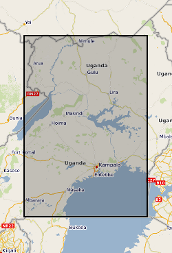
Borehole and transmissivity dataset, Uganda (NERC Grant NE/M008606/1)
This dataset comprises 655 borehole records and previously unanalysed pumping tests from across Uganda that were compiled from historical borehole records held within 9 district water offices. The dataset is a compilation of historical borehole records held within nine district water offices across Uganda. These data originated from numerous drilling campaigns undertaken by private contractors in each district to site and construct hand-pump borehole community water supplies between 2000 to 2018. In total over 1000 paper borehole records were initially collated and reviewed. This work was carried out over several months visiting the district water offices. Following a quality assurance procedure 655 records were transcribed to create a digital dataset. Each borehole record in the dataset contains a series of metadata alongside the pumping test data (e.g. pump depth, static water level, pumping rate and duration) including locational information (e.g. coordinates, water strike, borehole depth, borehole lithologies). The dataset is delivered as a series georeferenced site information within an MS Excel spreadsheet file.
Default
Identification info
- Metadata Language
- English (en)
- Dataset Reference Date ()
- 2022-06-08
University College London
-
Professor Richard Taylor
(
Department of Geography
)
Gower Street
,
London
,
WC1E 6BT
,
British Geological Survey
-
Enquiries
0115 936 3276
The Lyell Centre, Research Avenue South
,
EDINBURGH
,
LOTHIAN
,
EH14 4AP
,
United Kingdom
0115 936 3142
0115 936 3276
British Geological Survey
-
Enquiries
0115 936 3276
The Lyell Centre, Research Avenue South
,
EDINBURGH
,
LOTHIAN
,
EH14 4AP
,
United Kingdom
0115 936 3142
0115 936 3276
British Geological Survey
-
Enquiries
0115 936 3276
The Lyell Centre, Research Avenue South
,
EDINBURGH
,
LOTHIAN
,
EH14 4AP
,
United Kingdom
0115 936 3142
0115 936 3276
- Maintenance and update frequency
- notApplicable
- GEMET - INSPIRE themes, version 1.0
- BGS Thesaurus of Geosciences
-
- Groundwater
- NGDC Deposited Data
- Transmissivity
- Boreholes
- Keywords ()
- Keywords
-
- NERC_DDC
- Limitations on Public Access
- otherRestrictions
- Other constraints
- licenceOGL
- Use constraints
- otherRestrictions
- Other constraints
- The copyright of materials derived from the British Geological Survey's work is vested in the Natural Environment Research Council [NERC]. No part of this work may be reproduced or transmitted in any form or by any means, or stored in a retrieval system of any nature, without the prior permission of the copyright holder, via the BGS Intellectual Property Rights Manager. Use by customers of information provided by the BGS, is at the customer's own risk. In view of the disparate sources of information at BGS's disposal, including such material donated to BGS, that BGS accepts in good faith as being accurate, the Natural Environment Research Council (NERC) gives no warranty, expressed or implied, as to the quality or accuracy of the information supplied, or to the information's suitability for any use. NERC/BGS accepts no liability whatever in respect of loss, damage, injury or other occurence however caused.
- Other constraints
- Available under the Open Government Licence subject to the following acknowledgement accompanying the reproduced NERC materials "Contains NERC materials ©NERC [year]"
- Spatial representation type
- vector
- Topic category
-
- Geoscientific information
- Extent
-
UG
- Dataset Reference Date ()
- 2009
- Extent
-
UGA
- Dataset Reference Date ()
- 2009
- Extent
-
UGANDA [id=689000]
- Dataset Reference Date ()
- 1979
N
S
E
W
))
- Begin date
- 2000-01-01
- End date
- 2018-12-31
- Code
- WGS 84 (EPSG::4326)
Distribution Information
- Data format
-
-
MS Excel
()
-
MS Excel
()
- Resource Locator
- Data
- Resource Locator
- Digital Object Identifier (DOI)
- Resource Locator
- Data
- Resource Locator
- Digital Object Identifier (DOI)
- Quality Scope
- dataset
- Other
- dataset
Report
- Dataset Reference Date ()
- 2011
- Explanation
- See the referenced specification
- Degree
Report
- Dataset Reference Date ()
- 2010-12-08
- Explanation
- See http://eur-lex.europa.eu/LexUriServ/LexUriServ.do?uri=OJ:L:2010:323:0011:0102:EN:PDF
- Degree
- Statement
- The dataset is a compilation of historical borehole records held within nine district water offices across Uganda. These data originated from numerous drilling campaigns undertaken by private contractors in each district to site and construct hand-pump borehole community water supplies between 2000 to 2018. In total over 1000 paper borehole records were initially collated and reviewed. This work was carried out over several months visiting the district water offices. Following a quality assurance procedure 655 records were transcribed to create a digital dataset.
Metadata
- File identifier
- e104bac0-eba5-235c-e053-0937940accea XML
- Metadata Language
- English (en)
- Resource type
- dataset
- Metadata Date
- 2024-07-25
- Metadata standard name
- UK GEMINI
- Metadata standard version
- 2.3
British Geological Survey
Environmental Science Centre,Keyworth
,
NOTTINGHAM
,
NOTTINGHAMSHIRE
,
NG12 5GG
,
United Kingdom
+44 115 936 3100