 NERC Data Catalogue Service
Acoustics
Type of resources
Topics
Keywords
Contact for the resource
Provided by
Years
Formats
Representation types
Update frequencies
-
The first dataset consists of the data to accompany the paper 'Modelling acoustic scattering, sound speed, and attenuation in gassy soft marine sediments' by A. Mantouka, H. Dogan, P.R. White and T.G. Leighton. This paper was published as J. Acoust. Soc. Am. 140, 274 (2016); http://dx.doi.org/10.1121/1.4954753. The second dataset consists of the data to accompany an as-yet unpublished study, which will be entitled 'Acoustic wave propagation in gassy porous marine sediments: the rheological and the elastic effects' by H. Dogan, P.R. White and T.G. Leighton.
-
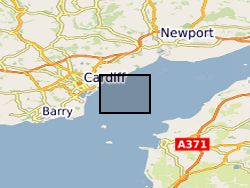
MEDIN Data. Within the project (WFA-CPC EMFF Protecting Our Seas), benthic and geophysical surveys were undertaken in the Severn Esturary/Môr Hafren SAC to explore the location of Sabellaria alveolata reefs, and collected bathymetry, sidescan sonar, AGDS and acoustic imagery data (ARIS) to identify areas of variable ground or potential features. A ten-day survey was undertaken in July 2020 to collect broad-scale acoustic data using an interferometric swath bathymetric system (GeoSwath Plus) and Acoustic Ground Discrimination System (RoxAnn™ AGDS). Twelve secondary survey areas were selected to be investigated in greater detail using high frequency sidescan sonar and an Acoustic Resonance Inspection System (ARIS Explorer 3000) camera in a second ten-day survey conducted in August 2020 (https://www.envision.uk.com/wp-content/uploads/2022/03/2018-1008-NRW-WFA-Protecting_Our_Seas_Final_Report_20210201.pdf) The data sets include: SSS (.tif) collected using Trident SeaStar MBES (.xyz) collected using GeoSwath Plus, AGDS (.csv and .asc) collected using RoxAnn™ AGDS ARIS imagery (.png and .mp4) collected using ARIS Explorer 3000 camera Shapefiles (.shp etc)
-
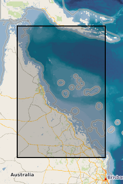
Four datasets for NERC grant NE/J023329/1, Paluma Shoals reef complex, Halifax Bay, central Great Barrier Reef, Australia. DATASET 1: Single Beam acoustic survey data. This dataset comprises the single beam acoustic data that was collected from transects across the Paluma Shoals reef complex, Halifax Bay, central Great Barrier Reef, Australia. The dataset comprises of depth measurements (m) and the latitudinal and longitudinal coordinates of 58,255 point samples across the study area. The dataset was used to construct Figure 1C in Morgan, K. M., Perry, C. T., Smithers, S. G., Johnson, J. A., & Daniell, J. J. (2016). Evidence of extensive reef development and high coral cover in nearshore environments: implications for understanding coral adaptation in turbid settings. Scientific Reports, 6. DATASET 2: Paluma Shoals core data (sedimentology and palaeoecology This dataset includes all collected sedimentary and coral palaeoecological data collected from cores from across the Paluma Shoals Reef Complex, Halifax Bay, central Great Barrier Reef, Australia. This includes 1) a list of the cores recovered, their geographic location and their depths; 2) data on the mud and carbonate content of the sediment matrix from each core; 3) grainsize data from each core; 4) data from thin section analysis from each delineated facies in cores; and 5) downcore data on coral constituent abundance. DATASET 3: Core radiocarbon dates This dataset comprises the radiocarbon dates obtained from coral samples from cores collected across the Paluma Shoals Reef Complex, Halifax Bay, central Great Barrier Reef, Australia. Dates are from the NERC Radiocarbon dating lab (SUERC) in East Kilbride. DATASET 4: Benthic video imagery This dataset comprises screen grab images collected along towed transects across the Paluma Shoals reef complex, Halifax Bay, central Great Barrier Reef, Australia. Each image has the relevant lat, long coordinates printed on the top right hand corner. The sites names (folders) relate to the sites described in the following paper: Morgan KM, Perry CT, Smithers SG, Daniell JJ and Johnson JA (2016) Extensive reef development within the “mesophotic” nearshore Great Barrier Reef: Evidence for intra-regional variations in coral resilience. Scientific Reports 6:29616. DOI: 10.1038/srep29616