 NERC Data Catalogue Service
Coasts
Type of resources
Topics
Keywords
Contact for the resource
Provided by
Years
Formats
Representation types
Update frequencies
-
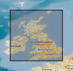
The BGS GeoCoast Dataset is a Geographic Information System (GIS)-based analysis for indicating multi-hazards and interdependencies within the coastal zone of Great Britain (not including Orkney and Shetland). GeoCoast represents the natural geological coastline (around the mainland of Great Britain) as if no coastal defences or made ground are present. This will be of particular value in areas where coastal defences are no longer maintained. GeoCoast will offer anyone with assets, or an interest in the coastline around Great Britain, access to easy-to-use datasets linked to geohazard data. This will allow users to interpret potential interdependencies in terms of erosion, flooding, habitat and other vulnerabilities. These datasets are divided into two data packages: Premium and Open datasets, which include the following information: The data is delivered in GIS ESRI point, polyline and polygon format (other formats available on request).
-
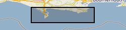
This is a 1:10,000 scale Bedrock geological map for some 800 km2 of the seabed across Weymouth Bay in Dorset. It joins seamlessly to the onshore BGS 1:10,000 scale Digital Geological Mapping (DiGMapGB-10) and therefore shows the coastal geology in detail. It comprises bedrock polygons, faults and limestone bed lines. The map was produced in 2015-16 by digitising against a seamless on- to offshore-shore elevation surface generated from high (1 m bin) resolution bathymetry and coastal Lidar data, collected as part of the Dorset Integrated Seabed Survey (DORIS) project and the Regional Coastal Monitoring Programme of England, made available by the Channel Coastal Observatory under the Open Government Licence. The map can be veiwed using the map viewer at www.bgs.ac.uk/research/marine/doris.html. This map has been produced under the auspices of the Marine Environmental Mapping Programme (MAREMAP), in collaboration between the BGS and the University of Southampton. The map itself should be referred to as: Westhead, R K, Sanderson, D J, Dix, J K. 2016. Bedrock map for the offshore Weymouth Bay area, with seamless coastal joint to BGS onshore (DiGMapGB-10) mapping. Bedrock Geology. 1:10 000 (Marine Environmental Mapping Programme, MAREMAP)
-
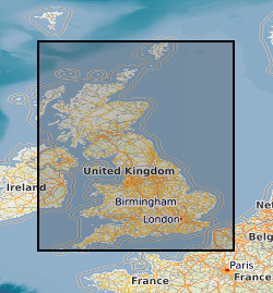
DiGBcoast v1.0, is a new supranational dataset documenting three decades of coastal change across Great Britain mainland (England, Scotland, and Wales) including the isle of Wight and Anglesey. This dataset has been produced using the publicly available optical Landsat-5,8 and Sentinel-2 missions over the period between 1984 to 2022 (38 years). It includes instantaneous waterlines and instantaneous tidally corrected to Mean Sea Level shorelines. DiGBcoast is made available to the public as free and open interactive data to support future coastal research and management across Great Britain.