 NERC Data Catalogue Service
Drilling
Type of resources
Topics
Keywords
Contact for the resource
Provided by
Years
Formats
Representation types
Update frequencies
Scale
-

Three borehole logs are presented that describe the material excavated from a slag deposit in Consett Co. Durham (ad pdf files). The boreholes were created by GeoSonic Ltd commissioned by Cardiff University in September 2017 as part of a UKRI funded project that explores CO2 uptake in slag. The drilling penetrated through 20 and 25m of material representing the extent of the heap to underlying natural ground. The methods used and samples recovered are described in Pullin et al., 2019 Environmental Science and Technology. 53 (16) 9502-9511. DOI: 10.1021/acs.est.9b01265. The deposited data include photographs of recovered material from one of the boreholes.
-
Whole rock geochemical data from the Alpine Fault Zone. These data have been generated from systematic sampling through the Deep Fault Drilling Project - Phase 1 rock cores and from analyses of cuttings retrieved during the Deep Fault Drilling Project - Phase 2. Geochemical analyses on the fault rocks to understand the conditions at which they were deformed. The dataset is associated with the UK component of a major international campaign, the Deep Fault Drilling Project (DFDP). to drill a series of holes into the Alpine Fault, New Zealand. The overarching aim of the DFDP to understand better the processes that lead to major earthquakes by taking cores and observing a major continental fault during its build up to a large seismic event.
-

This data was generated at the University of Kiel, Germany by Wolfgang Kuhnt, paid for by Dr Littler as part of her 2016 NERC Moratorium Award. The data comprises XRF-derived elemental abundances from two Holes (A and B) for International Ocean Discovery Program (IODP) Site U1448, spanning approximately the Pliocene period.
-

The borehole information pack from borehole GGA05, site 02 of the UK Geoenergy Observatories (UKGEOS) Glasgow facility. This release from the British Geological Survey (BGS) contains BGS and Drillers’ logs, cased hole and open hole wireline data, optical camera data, a listing of archived rock chips and a descriptive report. The mine water characterisation and monitoring borehole was drilled between 1st July and 11th October 2019 (start of drilling to casing installation date) to 88.5 m drilled depth. The cased borehole was wireline logged and hydrogeologically tested in January 2020. Rock chip samples were taken during the drilling process and have been archived at the National Geological Repository at BGS Keyworth. Further details can be found in the accompanying report http://nora.nerc.ac.uk/id/eprint/528052 DOI https://dx.doi.org/10.5285/714fe9fc-ce77-4479-8053-1c5fd4e86f06
-
The data shows the location of seabed and sub-seabed samples collected from the UK continental shelf, held by BGS. A BGS Sample Station is a general location at which sampling with one or more equipment types, such as borehole, grab, dredge, has been used. Historically, all deployment of equipment was recorded with the same coordinates so the data shown here will often show several sets of data at the same location. Newer data will begin to show distinct locations based on an equipment type. This layer shows all the BGS Sample Station Locations, including those where the Sampling was unsuccessful. The layers below are divided into distinct equipment types, plus a separate layer for unsuccessful sampling. BGS Sample Station Locations can have a wide range of potential information available. This can vary from a basic description derived from a simple piece of paper up to a complex set of information with a number of datasets. These datasets can include particle size analysis, geotechnical parameters, detailed marine geology, geochemical analysis and others. Prices are available on further enquiry.
-

The borehole information pack from borehole GGB05, site 05 of the UK Geoenergy Observatories (UKGEOS) Glasgow facility. This release from the British Geological Survey (BGS) contains BGS and Drillers’ logs, a listing of archived rock chips and a descriptive report. The environmental baseline characterisation and monitoring borehole was drilled between 5th July and 11th October 2019 (start of drilling to casing installation date) to 46 m drilled depth. The cased borehole was hydrogeologically tested in Febuary 2020. Rock chip samples were taken during the drilling process and have been archived at the National Geological Repository at BGS Keyworth. Further details can be found in the accompanying report http://nora.nerc.ac.uk/id/eprint/528084 DOI: https://dx.doi.org/10.5285/e0ec7462-b731-47c6-93d6-e4613fb44be0
-
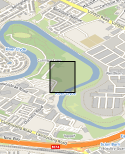
This summary borehole information release is for ‘as-built’ mine water and environmental baseline monitoring boreholes of the UK Geoenergy Observatories (UKGEOS) Glasgow facility at Cuningar Loop. The information pack from BGS contains a brief report with summary tables of locations, drilled depths, screened intervals and illustrative interpretations, and is accompanied with a spreadsheet and shapefile of the borehole locations and drilled depths. The purpose is to give potential users of the Glasgow Observatory an outline of the as-built infrastructure including condition of the target mine workings, as a summary of the more detailed information packs for each borehole. This dataset was updated in June 2020. Further details can be found in the accompanying report http://nora.nerc.ac.uk/id/eprint/526889
-

The borehole information pack from borehole GGA06r, site 02 of the UK Geoenergy Observatories (UKGEOS) Glasgow facility. This release from the British Geological Survey (BGS) contains BGS and Drillers’ logs, a listing of archived rock chips and a descriptive report. The environmental baseline characterisation and monitoring borehole was drilled between 3rd July and 2nd August 2019 (start of drilling to casing installation date) to 16 m drilled depth. The cased borehole was hydrogeologically tested in January 2020. Rock chip samples were taken during the drilling process and have been archived at the National Geological Repository at BGS Keyworth. Further details can be found in the accompanying report http://nora.nerc.ac.uk/id/eprint/528079 DOI https://dx.doi.org/10.5285/ccb1aabe-6062-4cb7-9731-535229316246
-

The borehole information pack from borehole GGA02, site 01 of the UK Geoenergy Observatories (UKGEOS) Glasgow facility. This release from the British Geological Survey (BGS) contains BGS and Drillers’ logs, cased hole wireline data, details on fibre-optic cable installation, a listing of archived rock chips and a descriptive report. The borehole was drilled between 17th June and 20th September 2019 (start of drilling to casing installation date) to 94.16 m drilled depth as a mine water characterisation and monitoring borehole. Unfortunately, during the final stages of construction grout entered inside the casing, the casing was damaged and the borehole is now available as a sensor testing borehole to 67.2 m. The cased borehole was wireline logged in January 2020. Rock chip samples were taken during the drilling process and have been archived at the National Geological Repository at BGS Keyworth. Further details can be found in the accompanying report http://nora.nerc.ac.uk/id/eprint/528076 DOI https://dx.doi.org/10.5285/189dac62-b720-4fde-8260-f129fb9b0233
-

Data from the IODP Expedition will be archived by the International Ocean Discovery Program, including all data generated during the shipboard palaeomagnetic and magnetic anisotropy analyses and all of the logging data (FMS tool, GBM data), plus associated explanatory notes. Shore based palaeomagnetic and magnetic anisotropy data, FMS---based reorientation parameters, and downhole magnetizations inferred from modelling of the GBM borehole magnetometer data will be made available to the international community via appropriate IODP Data Reports (in addition to primary journal articles). Data Includes: Shipboard cryogenic magnetometer data Shipboard and shore based discrete sample remanence data Shipboard and shore based magnetic anisotropy data FMS---based reorientation parameters Magnetic parameters modelled using borehole magnetometer data