 NERC Data Catalogue Service
Geological maps
Type of resources
Available actions
Topics
Keywords
Contact for the resource
Provided by
Years
Formats
Representation types
Update frequencies
Scale
-
Manuscript geological maps produced by the Survey geologists or other recognised geologists on County Series (1:10560) and National Grid (1:10560 & 1:10000) Ordnance Survey base maps of Great Britain. A small number are produced at larger scale. Similar maps compiled from other sources. Maps produced since the 1850's, current holdings over 35,000 maps, all now scanned and available internally as image files.
-

This dataset comprises scanned images of the manuscript geological maps produced by the Survey geologists or other recognised geologists on County Series (1:10560) and National Grid (1:10560 and 1:10000) Ordnance Survey base maps. The collection also includes similar maps compiled from other sources. Currently the dataset contains over 35,000 scanned images. Original maps date from the 1860s, and cover surveys in Great Britain, scanning started in 2003.
-
Photographic negatives of Geological map 'Standards', manuscript and published maps produced by the Survey on County Series (1:10560) and National Grid (1:10560 & 1:10000) Ordnance Survey base maps. Current holdings over 41,000 maps for Great Britain. The majority of maps were scanned in 2004, any new maps produced are scanned and added to the collection. This is essentially a back up collection for disaster recovery.
-

Index to BGS geological map 'Standards', manuscript and published maps for Great Britain produced by the Survey on County Series (1:10560) and National Grid (1:10560 & 1:10000) Ordnance Survey base maps. 'Standards' are the best interpretation of the geology at the time they were produced. The Oracle index was set up in 1988, current holdings are over 41,000 maps. There are entries for all registered maps, but not all fields are complete on all entries.
-

Geological map 'Standards', manuscript and published maps of Great Britain produced by the Survey on County Series (1:10560) and National Grid (1:10560 & 1:10000) Ordnance Survey base maps. Maps produced since the 1860's, current holdings over 41,000 maps, all now available internally as image files.
-

Index to manuscript geological maps produced by the Survey geologists or other recognised geologists on County Series (1:10560) and National Grid (1:10560 & 1:10000) Ordnance Survey base maps. The index was set up in 1991. Current holdings for Great Britain are over 35,000. There are entries for all registered maps but the level of detail depends on nature of original Survey, ie not all fields are complete for all entries.
-
The Quaternary deposits thickness dataset is a digital geological map across the bulk of the UK Continental Shelf (UKCS), for areas up to a water depth of 200m, which shows the thickness of the deposits over bedrock in three categories: <5m, 5-50m, and >50m Quaternary cover. These depth bands were picked because they represent the horizons that have impact on offshore infrastructure deployment. The map is derived from (unpublished) BGS 1:1000000 scale Quaternary digital geological mapping. The map was produced in 2014 in collaboration with, and co-funded by, The Crown Estate as part of a wider commissioned project to assess seabed geological constraints on engineering infrastructure across the UKCS. The data are held by the BGS as an ESRI ArcGIS Shapefile.
-

The collection of map series held by BGS which correspond to the outputs of discrete projects. The maps often focus on a specific theme, and / or may have limited spatial coverage. The thematic maps include: - Applied Geology Maps (AGMs), also known as Environmental Geology Maps (EGMs) or Planning for Development maps, which were produced between 1975 and 1996 as part of 'geological background for planning and development' and preliminary sand and gravel projects carried out on behalf of the Department of the Environment, Scottish Development Department and the Scottish Office. - Industrial Minerals Assessment Unit (IMAU) Mineral Assessment Report maps, published between 1971 and 1985 by the Institute of Geological Sciences. - Oil-shale Seam Maps of the Lothians, published between 1977 and 1982 by the Institute of Geological Sciences (IGS) in Edinburgh.
-
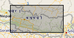
Raster (TIFF) file showing the simplified main bedrock geology units that comprise a ~45,000 km2 region of central-eastern Nepal.
-

This layer of the map based index (GeoIndex) shows the availability of 1:50000 series paper geological maps. For England and Wales (and Northern Ireland), map sheets normally cover an area 30 km east-west and 20 km north-south; in Scotland the coverage is 20 km east-west and 30 km north-south. The 1:50 000 geological map grids are based on an early Ordnance Survey 1:63 360 (one inch to one mile) scale map grid and are not related to the current Ordnance Survey 1:50 000 map sheets. Maps are normally available in both flat and folded formats.