 NERC Data Catalogue Service
Iron
Type of resources
Topics
Keywords
Contact for the resource
Provided by
Years
Formats
Representation types
Update frequencies
Scale
-
This national digital GIS product produced by the British Geological Survey indicates the potential for leakage to have a negative effect on ground stability. It is largely derived from the digital geological map and expert knowledge. The GIS dataset contains seven fields. The first field is a summary map that gives an overview of where leakage may affect ground stability. The other six fields indicate the properties of the ground with respect to the extent to which hazards associated with soluble rocks, landslides, compressible ground, collapsible ground, swelling clays and running sands will be increased due to leakage. The data is useful to asset managers in water companies, local authorities and utility companies who would like to understand where. and to what extent, leaking underground pipes or other structures may initate or worsen ground stability.
-
This collection includes the elastic calculations of the hcp-Fe-Si-S-C alloy system. NERC grant NE/M015181/1 - Pre melting in iron and iron alloys: ab initio calculations and high P-T experiments on iron, iron alloys and other materials
-

The vast majority of palaeomagnetic recordings held in rock and meteorites are contained in small inhomogeneously magnetised particles that have a single-vortex (SV) domain state. The reliability and fidelity of the magnetic recording in these particles can only be determined using a numerical micromagnetic approach. This data set provides the first comprehensive examination of domain state as a function of grain size, grain shape and temperature for both magnetite and iron. The results show that SV domain states are highly stable, and in some cases more stable than their ‘ideal’ uniformly magnetized counterparts. With the data sets in this archive it is possible to determine the magnetic recording and stability characteristics of assemblies of grains that can be matched to a wide variety of grain distributions found in terrestrial rocks and meteorites.
-
The dataset is a Soil Corrosivity Map for the U.K. based on the BGS DIGMapGB-PLUS Map. The creation of this dataset involves scoring the Soil Parent Material types for five different attributes that contribute towards the corrosion of underground assets. These are (i) high or low soil pH, (ii) general soil moisture, (iii) the likelihood that soil saturated and undergo periods of anaerobic conditions, (iv) the presence of sulphides and sulphates and (v) the resistivity of the soil parent material. The scoring of each of these parameters was undertaken based on the Cast Iron Pipe Association (CIPA) (now the Ductile Iron Pipe Research Association, DIPRA) rating system. By combining the scores of each parameter a GIS layer has been created that identifies those areas that may provide a corrosive environment to underground cast iron assets. The final map has been classified into three categories signifying: 'GROUND CONDITIONS BENEATH TOPSOIL ARE UNLIKELY TO CAUSE CORROSION OF IRON', 'GROUND CONDITIONS BENEATH TOPSOIL MAY CAUSE CORROSION TO IRON', 'GROUND CONDITIONS BENEATH TOPSOIL ARE LIKELY TO CAUSE CORROSION TO IRON'. The dataset is designed to aid engineers and planners in the management of and maintenance of underground ferrous assets.
-
These data are (1) porewater extractions of cores of the permafrost and active layer of Adventdalen, Svalbard, (2) solid-phase extractions of the same cores, and (3) in-situ porewater sampling from the end of the summer, 2017. The aqueous parameters are: major ions (Ca2+, Mg2+, Na+, K+, Cl-, NO3-, SO42-), Fe(aq), Mn(aq), aqueous CH4 and CO2 concentrations, delta 13C- CH4, acetate, propionic acid, isobutyric acid, butyric acid, isovaleric acid, valeric acid, isocaproic acid, caproic acid, heptanoic acid, pH, oxidation-reduction potential, dissolved oxygen and alkalinity. The solid parameters are: organic carbon, nitrogen, acid volatile sulphur (AVS), chromium-reducible sulphur (CRS), amorphous and nanoparticulate iron (oxyhydr)oxides, crystalline iron (oxyhydr)oxides, iron bound in carbonates, and magnetite. Funding was provided by the NERC grant NE/M019829/1.
-
This dataset represents the first publication of complete national maps from the Geochemical Baseline Survey of the Environment (G-BASE) and TellusNI projects, whose aim was to conduct a national geochemical survey of the United Kingdom in order to improve understanding of our geology and environment and provide quantitative evidence against which to gauge future environmental change. This dataset consists of a series of interpolated raster (ASCII grid) maps displaying the concentrations of a suite of chemical elements (and oxides) in the stream sediments of the United Kingdom. The chemical elements are as follows: Arsenic, Barium, Calcium (CaO), Chromium, Cobalt, Copper, Iron (Fe2O3), Lanthanum, Lead, Magnesium (MgO), Manganese (MnO), Nickel, Potassium (K2O), Rubidium, Uranium, Vanadium, Zinc and Zirconium.
-
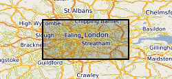
The London Earth data is part of a nationwide project to determine the distribution of chemical elements in the surface environment, namely Geochemical Baseline Survey of the Environment (G-BASE). London Earth focuses on the soil of the capital city, the limits of the survey being defined by the Greater London Authority (GLA) administrative boundary. Chemical elements have been determined by X-ray fluorescence spectrometry (XRFS) at the laboratories of the British Geological Survey (BGS) in Keyworth, Nottingham. These results are presented as a MS Excel file.