 NERC Data Catalogue Service
Isotopes
Type of resources
Topics
Keywords
Contact for the resource
Provided by
Years
Formats
Representation types
Update frequencies
-
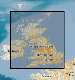
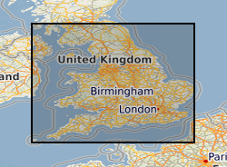
This website provides interactive access to geospatial isotope data for Great Britain. The site includes isotope data for strontium, oxygen and sulphur distributions across Great Britain. The user can input isotope measurements from a sample and the website will compare it with British data distributions and provide a downloadable map of areas that match the composition of the unknown. The project is rooted in archaeological studies but has applications in the modern world of food traceability.
-
The dataset consists of a spreadsheet containing whole rock geochemistry (Major and trace elements, Hf isotopes) from 7 samples and zircon U-Pb, O, Hf isotope and trace elements compositions (>200 spots on zircons from 7 samples) analysed by Ion Microprobe (NERC EIMF) and MC-LA-ICP-MS (NIGL). The samples are Eoarchaean amphibolite-facies mafic gneisses and a pegmatite as well as granulite-facies mafic gneiss and migmatite (melano- and leucosome) from the Kapuskasing uplift in Ontario, Canada.
-

This data set contains a record of nitrate concentrations and isotopic composition present within the drip waters and speleothem carbonate deposits of Cueva-cubío del Llanío, northern Spain. Data were collected between 2018 to 2020, and specifically address the nitrate composition of the cave drip waters, pool waters, rocks, soil, vegetation and contemporary speleothem carbonate. Calculations are also undertaken to assess the partitioning of nitrate between cave drip water and speleothem carbonate deposits. Data pertaining to speleothem nitrate content also extend to other cave locations (Pooles cavern, UK; Brown's Folly Mine, UK, Ease Gill Caverns, UK; Rukiesa cave, Ethiopia; Cueva Perlas, N. Spain). Sample analysis was performed at Lancaster University and the UK Centre for Ecology and Hydrology under NERC facility access grant LSMSF\CEH\L\125\11\2018. The data presented represent the full underlying dataset to Wynn et al., 2021, Chemical Geology: DOI.org/10.1016/j.chemgeo.2021.120172.
-
Dataset contains an interannual to sub centennial resolution record of carbonate oxygen and carbon isotopes, bulk sediment geochemistry and sedimentology from a 2.95 metre-long core (YC2) from Yaal Chac. The core was dated using a combination of radiocarbon dates and short-lived radio-isotopes. Data are presented in Metcalfe et al (2022) Quaternary Science Reviews https://doi.org/10.1016/j.quascirev.2022.107445
-

Database of samples taken from the Norham Westmains Farm borehole for isotope, thin section, palynology and fossil analysis. Westmains Farm, Norham, Berwick-upon-Tweed NT 91589 48135. BGS borehole ID NT94NW20.
-

Clumped isotope analyses, raw data, replicates and temperatures calculated using the empirical calibration of Wacker et al. (2014), recalculated using the [Brand] isotopic parameters.
-
Chemical analysis of pyroxenes and BSE-SEM images from pumices and lava flows from Popocatepetl Volcano, Mexico. Whole rock isotope data from pumices and lava flows from Popocatepetl Volcano, Mexico.
-
This file documents the sulphur isotope data, and the manner in which it has been processed, to supply the reference data for isotope domains of the Isotope biosphere domains GB (V1) map. It includes a summary of the analytical methods used to determine the isotope ratios though time.
-

During the drilling of an exploration well in the 1960s, an underground blowout occurred near Sleen, The Netherlands. During approximately 25 months, near-continuous leakage of large amounts of natural gas was released into the subsurface. After the blowout, the local drinking water production company installed a network of groundwater monitoring wells to monitor for possible adverse effects on groundwater quality at the blowout site. Today, more than 50 years after the blowout, the groundwater is still impaired. Data has been correlated with previously published data by Schout et al. (2018) covering description of geology and well depths. During two fieldtrips (November 2019 & October 2020) water samples were collected from several wells covering: - Bulk gas compositions (methane, ethane, propane, oxygen, nitrogen, CO2, Argon). Bulk isotope compositions of methane (δ13C & δH), carbon dioxide (δ13C) and nitrogen (δ15N). - Methane clumped isotope compositions (ΔCD & ΔDD). - Inorganic parameters (hydrocarbons, anions, cations, DOC, alkalinity, nitrate and ammonium). The dataset was created within SECURe project (Subsurface Evaluation of CCS and Unconventional Risks) - https://www.securegeoenergy.eu/. This project has received funding from the European Union’s Horizon 2020 research and innovation programme under grant agreement No 764531.