 NERC Data Catalogue Service
Monitoring
Type of resources
Topics
Keywords
Contact for the resource
Provided by
Years
Formats
Representation types
Update frequencies
Scale
-

This data set consists of sets of qualitative data in the form of vulnerability questionnaires (referred to as tool 1) and interviews (referred to as Tool 2) from 4 communities - 2 in Northern Ghana and 2 in Burkina Faso.
-
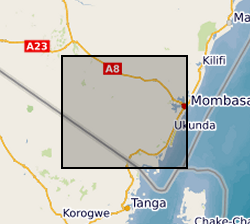
The data sets contain the daily record of meters of groundwater columns for 7 Heron logger transducers installed in different boreholes and wells in the study area. Missing data denoted -9999. The Barlog data for atmospheric pressure (Atmospheric Pressure data measured by Heron Barologger for the period of April 2014 to November 2018 at Munje Jabalini.) is also included. "Uncomp.HT.WTR. Above Transducer" corresponds to the actual pressure the dipperLog is measuring. "Barologger Data" corresponds to the Barlog data for atmospheric pressure at Munje Jabalini "Comp.Depth.WTR Below the Datum" is the "Depth below datum" entered in the logger setup less "Comp.HT.WTR. Above Transducer". The data was collected by Albert Folch and Nuria Ferrer (UPC), Mike Lane and Calvince Wara (Rural Focus Ltd). The PI on the Gro for GooD project was Prof. Rob Hope, University of Oxford.
-
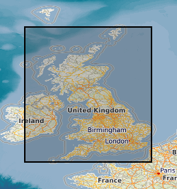
Digital hourly mean values of the Geomagnetic field elements from Lerwick, Eskdalemuir, Abinger and Hartland Observatories. Eskdalemuir data are available from 1911, Lerwick from 1926, Hartland from 1957 and all three are available up to yesterday's date. Values from Abinger (1926-1956) are available on request. Most data are definitive, but recent data (within the last 203 years) are provisional and may be corrected in the future. Values of declination (D), horizontal intensity (H) and vertical intensity (Z) are available. The units of declination are degrees. Declination is negative when west of true north. The units of horizontal intensity and vertical intensity are nT (nanotesla). Vertical intensity is positive in the downwards direction. The data from these observatories will not only aid scientific research into rates of change of the magnetic field and increase the accuracy of the BGS Global Geomagnetic Model, but will also provide data to exploration geophysicists engaged in current and future oil exploration.
-
This set of data is the second set of impact interviews conducted with the target communities of the BRAVE project. The interviews are transcriptions in Microsoft word. The communities involved in the data collection were from Tomo and Poa in Burkina Faso and Jawani and Tariganga in Ghana. There are 32 interviews from Burkinabe community members, and 23 from the Ghanaian communities. Individuals were selected based on their participation in the BRAVE field activity of the Farmer Voice Radio. The data was collected between October 2019 and February 2020 by the local researchers. This data methodology was built on the initial vulnerability assessments, and include questions around behaviour change and income change based on the BRAVE communities activities of ground water measurement and water management strategies. This data shows behaviour and livelihood change within the communities and due to these activities. This is final qualitative impacts dataset from the BRAVE project. Previous linked data sets include the baseline vulnerability assessments and the first round of impact interviews. BRAVE: Building understanding of climate variability into planning of groundwater supplies from low storage aquifers in Africa BRAVE is a ‘Consortium’ research project is part of the UPGro (Unlocking the Potential of Groundwater for the Poor) programme.
-
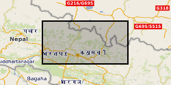
1. Rainfall (0.2 mm tipping bucket), accelerometer (OEM) and extensometer (string potentiometer) data from 10 instruments deployed across ground cracks in Sindhupalchok, Nepal in the aftermath of the 2015 earthquake. Data is provided in *.csv format, to include for each instrument: date, rainfall, extension(raw/min/max/mean/std), x(raw/min/max/mean/std), y(raw/min/max/mean/std), z(raw/min/max/mean/std). 2. Shapefiles of landslide mapping in the Upper Bhote Kosi valley, Sindhupalchok, Nepal, Including immediately post-earthquake (pre-monsoon), and post-2015 monsoon.
-

This excel spreadsheet contains P-wave and S-wave velocity and attenuation data calculated with a novel rock physics model for hydrate bearing sediments. The model has been published in: Marín-Moreno, H., S. K. Sahoo, and A. I. Best (2017), Theoretical modeling insights into elastic wave attenuation mechanisms in marine sediments with pore-filling methane hydrate, Journal of Geophysical Research: Solid Earth, 122(3), 1835-1847, doi:10.1002/2016JB013577.
-

This review details the laboratory experiments that have investigated leakage of geologically stored CO2 (as of June 2013). These experiments have covered a range of leakage factors. Knowledge of these factors can both compliment and help inform any future experiments at the QICS site. As such, the report details what experiments have been performed in the lab to date, how lab experiments can inform QICS and how QICS could inform laboratory experiments. Grant number: UKCCSRC-C1-31.
-

Here, we provide data corresponding to the experimental conditions used, the results gained via electron microprobe for natural and experimental volcanic samples. Mass balance calculations and a compilation of monitoring data for recent explosive eruptions.
-

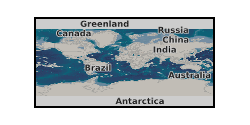
Collection of annual publications from the global network of magnetic observatories. They typically contain tabulations of hourly, monthly and annual mean values of the geomagnetic elements. Contains all magnetic observatory year books held by the World Data Centre for Geomagnetism (Edinburgh).
-

This poster on the UKCCSRC Call 1 project QICS2 Scoping Project: Exploring the Viability and Scientific Opportunities of a Follow-On Marine Impact Project was presented at the CSLF Call project poster reception, London, 27.06.16. Grant number: UKCCSRC-C1-31. The world's first sub-seabed CO2 release experiment was completed in 2014, offshore from Oban (Scotland). The project, known as QICS (Quantifying and Monitoring Potential Ecosystem Impacts of Geological Storage), mimicked the formation of a small-scale CO2 leak into sediments near the seabed. In 2012, CO2 was continuously injected into the sediments for 37 days, releasing a total of 4.2 tonnes of CO2. The QICS1 experiment was first of its kind, and was highly successful, enabling: i. field testing of monitoring technologies to detect CO2 against a measured baseline ii. assessment of environmental and ecosystem impacts of leaked CO2 (within the sediment and water column) iii. the flow and fate of CO2 in sediments, and dispersion and dilution of CO2 in seawater, to be explored.