 NERC Data Catalogue Service
Seismic epicentre
Type of resources
Topics
Keywords
Contact for the resource
Provided by
Years
Formats
Representation types
Update frequencies
-
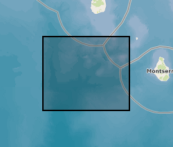
Earthquake hypocenters for all earthquakes detected on Montserrat by the Montserrat Volcano Observatory seismic network from July 1995 to February 2018 inclusive. Information includes: Origin Time, Latitude, Longitude, Depth, Hypocenter Errors, RMS and the number of stations used for each location.
-

This data set contains receiver functions calculated from three-component waveform data available in IRISDMC from 2000 to 2019. The waveform data are for earthquakes greater than magnitude 6.0, depth smaller than 100 km, and epicentral distances between 30 and 95 degrees. The raw waveform data are first converted to displacement and high pass filtered with a corner frequency of 0.02 Hz. Then the waveforms are windowed 20 s before and 400 s after the P arrival for analysis. The vertical-, north- and east-components are rotated to produce the L-, Q-and T-components. Subsequently, the [-20 s, 60 s] portion around the P arrival on the L-component is cut out as a parent waveform and deconvolved from the full L- and Q-components to produce the L- and Q-receiver functions. The data set is organized by year. The receiver functions in each year are compressed into a zip file named by the year when the waveforms were recorded. The receiver functions are in SAC format (https://seiscode.iris.washington.edu/projects/sac), which can be read using the Seismic Analysis Code (https://ds.iris.edu/ds/nodes/dmc/forms/sac/) or the Obspy package (https://github.com/obspy/obspy). The filename contains information of the origin time of the earthquake, the name of seismic network, the name of the seismic station, and component. For example, in the file name ‘TA.Z59A..BHL.M.2013.059.1405.SACD.01’, ‘TA’ stands for the network name, ‘Z59A’ is the station name, ‘BHL’ means the L component, ‘2013.059.1405’ means the earthquake occurred at 14:05 on the 59th day of the year 2013.
-
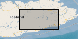
The dataset contains 3-component seismic data from seismometers deployed for one year Sept 204-August 2015 following the dyke intrusion from Bardarbunga which led to a 6 month long eruption at Holuhraun. The data is in miniseed format, archived at SEIS-UK and IRIS. The locations of all the microearthquakes we have identified from this data are published in Supplementary Information of Ágústsdóttir et al. (2016) [approx. 31,000 events from the Bardarbunga dyke], in Greenfield et al. [approx. 70,000 events from the Askja-Herðubreið area], and in Hudson et al. (2017), where they are publicly available for download. Ágústsdóttir, T., Woods, J., Greenfield, T., Green, R. G., White, R. S., Winder, T., Brandsdóttir, B., Steinthórsson, S. & Soosalu, H. (2016). Strike-slip faulting during the 2014 Bárðarbunga-Holuhraun dike Intrusion, central Iceland. Geophysical Research Letters, plus Supplementary Information, 43, 1495-1503, doi: 10.1002/2015GL067423 Greenfield, T., White, R. S., Winder, T. Ágústsdóttir, T. Seismicity of the Askja and Bárðarbunga volcanic systems of Iceland, 2009-2015, Journal of Volcanology and Geothermal Research, submitted 2017. Hudson, T. S., White, R. S., Greenfield, T., Ágústsdóttir, T., Brisbourne, A. & Green, R. G. (2017). Deep crustal melt plumbing of Bárðarbunga volcano, Iceland, Geophysical Research Letters, 44, doi: 10.1002/2017GL074749