 NERC Data Catalogue Service
Seismic monitoring
Type of resources
Topics
Keywords
Contact for the resource
Provided by
Years
Formats
Representation types
Update frequencies
Scale
-
Homogenised catalogues of microseismicity and pumping data from the PNR-1z and PNR-2 injection wells
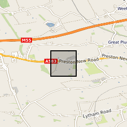
Microseismicity catalogues and fluid injection rate data recorded at the Preston New Road (Lancashire, UK) unconventional shale gas site during and after hydraulic fracturing of the PNR-1z and PNR-2 wells. Homogenised seismic catalogues include events recorded by the combined downhole and surface networks operated by the operator (Cuadrilla Resources Ltd.) and the British Geological Survey. Injection rate values are as initially reported by Cuadrilla Resources Ltd. The original datasets were provided by the UK Oil and Gas Authority (OGA).
-

The borehole information pack from borehole GGC01, site 10 of the UK Geoenergy Observatories (UKGEOS) Glasgow facility. This final data release pack from BGS contains geophysical (MSCL-S), Near Infrared (NIR) and X-ray Fluorescence (XRF; mineralogical and chemical) core scan and core-wireline depth integration data, in addition to sedimentology, discontinuity and engineering logs, core scan optical and X-ray images, composite and digital wireline logs, drillers' summary logs and prognosis, sample recovery information spreadsheets and daily drillers' borehole records that were contained within the now-superseded intermediate data release. The cored, seismic monitoring borehole was drilled between 19 November and 12 December 2018 to 199m producing a core of 102 mm diameter. The borehole was wireline logged in December 2018 and a string of 5 seismometers were installed in February 2019. A range of fluid, water and core samples were taken during the drilling process. The borehole information pack- final release contains a range of logs on the core as well as images and scans of that core, these data were acquired in the first half of 2019 and late 2020/early 2021. The final data release for GGC01 includes: 1. UKGEOSGlasgow_GGC01_Final.zip file that includes the majority of the various data files, including files from the intermediate and initial data packs. 2. UKGEOSGlasgowGGC01_slabbedhighresimages.zip that contains the slabbed core optical images, 51GB in size. 3. Intermediate Borehole Information Pack - Part Two, high resolution whole core optical and radiographic images https://doi.org/10.5285/0b49f25b-a5d6-401c-98ff-397ad9ee9ed1 71GB in size, already released. Further details and model limitations can be found in the accompanying report http://nora.nerc.ac.uk/id/eprint/530762
-
This layer of the map based index (GeoIndex) shows the location of earthquakes within the UK. The historical catalogue has been compiled, in general, from macroseismic observations (ie felt effects). Before 1700, only earthquakes with magnitudes of 4.0 ML or greater are included. After 1700, all known events with magnitudes of 3.0 ML or greater are included together with some other, smaller ones. Accuracies of magnitude, location, and origin time vary with the quality of information available for this period as they do for instrumental measurements in the post 1970 period. In that case, variations are largely a function of the seismograph station coverage, which has been improving up to the present day.