 NERC Data Catalogue Service
Tsunamis
Type of resources
Topics
Keywords
Contact for the resource
Provided by
Years
Formats
Representation types
Update frequencies
-
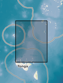
Tsunami trimlines identified across different islands of the Tonga archipelago. Trimlines have been used as a reference land feature following the January 2022 Tonga tsunami event that ripped off vegetation and built-up areas. Trimlines are distinctive limits between an area with sand coverage, vegetation destruction, and soil erosion on the one hand, and the unaffected natural vegetation on the other. This distinction provides a good landmark to map the inundation width and the landward extension of tsunami runup. In this case, the trimlines have been manually delineated by BGS - Earth Observation team using different high-resolution satellite datasets both optical (KompSat, Planet, Pleiades, WorldView) and radar (TerraSAR-X). Trimlines are well known from task-force publications documenting recent tsunami detection efforts and provide key information to support tsunami triggering mechanism models. For more info, see https://www.usgs.gov/media/images/tsunami-terms and Scheffers et al. (2012), https://doi.org/10.1007/s11069-010-9691-6
-
Numerical models of mass flows and tsunamis that they generated with their entrance in the sea. The mass flows propagate in the Sciara del Fuoco of Stromboli. The mass flows are not real events, but are rather used as a sensitivity analysis to examine tsunamigenic potential of mass flows of landslides and pyroclastic flows of different durations, volumes and coherence. The data was generated with the two fluid version of the Volcflow model. The material includes tsunami height measurements (plotted as well as raw data) for each run recorded by virtual gauges located around the island (map of gauges included), maximum wave height data in the area around the island and at the shores, a video visualisation of the mass flows and resultant tsunami waves, and a figure of the final deposit from each modelled mass flow. The numerical model simulations were carried out by Symeon Makris. The Volcflow code is not included in the submitted material but it is open source and can be downloaded here: https://lmv.uca.fr/volcflow/
-
Single Channel seismic data, Sound source - 8kJ Sparker; Recorder - EG&G 8 element marine hydrophone (streamer), stored in jpeg and SEGY files. Multibeam bathymetric data recorded by Teledyne Reson T20-P Multibeam echosounder (MBES) 200 - 400kHz. Positioning system using Differential Global Positioning System (DGPS) Trimble SPS 461 with OmniSTAR signal correction and computer-based navigation/data acquisition system with Qinsy Acquisition software. Hunt, J.E., Tappin, D.R., Watt, S.F.L., Susilohadi, S., Novellino, A., Ebmeier, S.K., Cassidy, M., Engwell, S.L., Grilli, S.T., Hanif, M., Priyanto, W.S., Clare, M.A., Abdurrachman, M., Udrekh, U., 2021. Submarine landslide megablocks show half of Anak Krakatau island failed on December 22nd, 2018. Nature Communications 12, 2827.
-
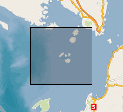
The data set comprises single channel seismic from the Sunda Strait, Indonesia. The data were acquired in 2019 to research the 1883, Krakatau volcanic eruption.